Twin buttes
| Diorama: | Cimarron - inclueds Twin Buttes, Cimarron River and Copperhead Canyon |
| Owner Name: | Razor |
| Sponsor: | Razor |
| Date Built: | 2002 |
| Date Updated: | |
| Status: | Active |
| Module Type: | 4' standard module |
| Length: | 4' |
| Width: | 2' |
| Skyboard: | 12" laminate |
Track
| Code | Brand | Turnouts | Crossovers | Passing Sidings | Yard Tracks | Industrial Spurs | Other Tracks |
|---|---|---|---|---|---|---|---|
| 80 | Atlas | none | none | none | none | none | none |
Electrical
| Wire | Connector | 110V | |
|---|---|---|---|
| Red | 12 gauge | PP-30 | Yes |
| Yellow | 12 gauge | PP-30 | Yes |
| Blue | 12 gauge | PP-30 | Yes |
| Other |
| DCC Equipment: | none |
| Powered Accessories: | none |
| Designer | Carpentry | Track | Wiring | Scenery | Oklahoma Scene | Route 66 Scene | Prototype RR |
|---|---|---|---|---|---|---|---|
| Razor | Razor | Razor | Razor | Razor |

|
|
Sign Board
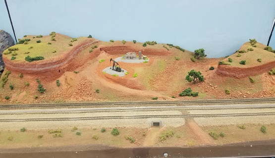
| This scene models the terrain found along US 412 west of Orienta, Major County, Oklahoma, near the ATSF line. Called the Glass Mountains, these red earth buttes with cap-rock rims of gypsum and sparkling selenite crystals rise 80 scale feet from the basin floor. They are part of the Blaine Escarpment, a large gypsum formation extending across much of western Oklahoma along the Cimarron River. The side of one of the buttes is cut out for a western Oklahoma oil well location. The red earth used on the modules is real Oklahoma red soil collected from an oil well location near Woodward, Oklahoma. |
Description & History
| The flat area in the center of the module is a drilling well location. |